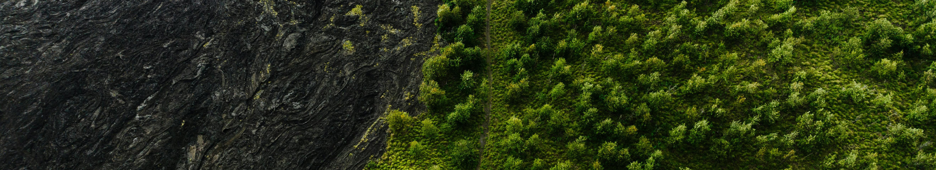
LiDAR (Light Detection and Ranging) is a remote sensing technology that uses laser pulses to measure distances and map the land's surfaces, as well as above-ground features (such as vegetation and infrastructure), creating highly accurate three-dimensional models of the Earth's surface. It is widely used across industries such as mining, utilities, forestry, engineering, and urban planning.
Aerometrex is one of Australia’s leading providers of Airborne Topographic LiDAR Data, offering high-resolution elevation models that capture land surfaces, vegetation, and built infrastructure in stunning detail. Topographic LiDAR Point Clouds are classified into a set of standard classes so that insights can be derived about elevation and topography, vegetation and built infrastructure.
With LiDAR technology, there are always interesting, novel and new ways in which it is being used across the world. We recently sat down with our Product & Program Manager, Dr Sam Holt, to ask him, "What else is being measured across the globe with LiDAR?”. Below are some interesting examples and stories behind each that he shared with us.
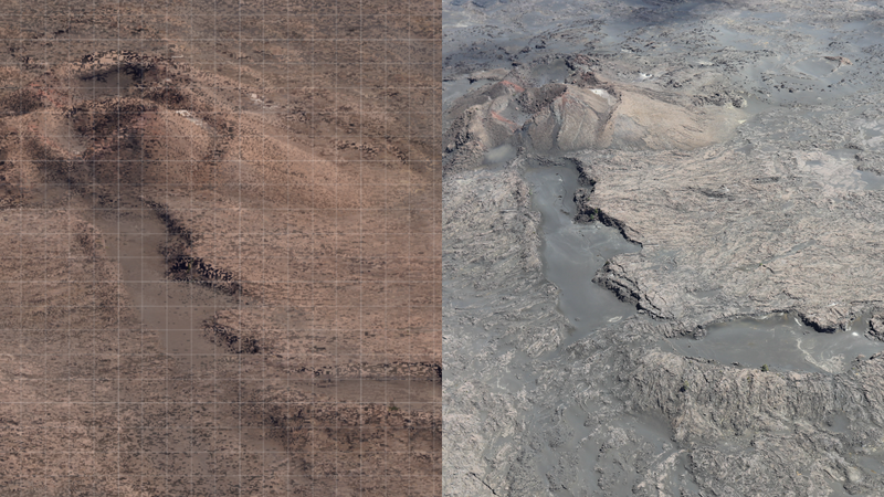
Monitoring Active Volcanoes
Active volcanic systems are some of the most dynamic places on Earth, with eruptions and lava flows constantly changing the morphology of the landscape. Additionally, due to the very nature of active volcanoes, volcanologists are not too keen to stand too close during ongoing eruptions to gather critical data. As a result, some monitoring agencies, such as the Hawaiian Volcano Observatory, utilise Airborne LiDAR data to generate high-accuracy elevation models. Such datasets can be critical in helping agencies monitor the active volcanoes and support natural hazard assessments and response.
Sam's passion for volcanoes is well known at Aerometrex, but we learnt that the first time he was ever exposed to LiDAR data was when he spent some time at the Hawaiian Volcano Observatory in the mid-2010s during his PhD. He had the opportunity to see some Terrestrial LiDAR data of the vent within the Halemaʻumaʻu at the Kilauea Caldera. Sam says, "Later on in my PhD, I went on to use LiDAR data for the very first time, making a map of littoral cones along the southern coast of the Big Island (admittedly a poor map as I was self-taught in ArcGIS Pro at the time)."
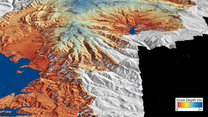
Mapping Regional Ice Packs
Over the recent years at Aerometrex, some of the projects that have required the most detailed operational planning have been large surveys across the alpine regions of Australia, where the company needed to make detailed plans to avoid snow cover and preserve data quality.
In June 2024, Sam had the pleasure of meeting one of the Co-founders of Airborne Snow Observatories, Jeffrey Deems, and learned a lot about the work they do in forecasting snowmelt runoff using Airborne LiDAR data.
It was interesting that while our flight operations team are doing their best to avoid snow in Alpine Victoria, others using the same sensor technology are seeking out snow for surveys for very different applications.
The Australian ICSM LiDAR specifications highlight that water in the environment can cause difficulties in the collection of Airborne LiDAR data, including statements such as “LiDAR capture must be undertaken without cloud, snowfall or other atmospheric interferents present…” and “The surface should be free from flooding or extensive inundation, snow cover and ice build-up…”. So, it may be a surprise that Airborne LiDAR is one technology used to map snow depth across large areas. Accurate measurements of snow depth and subsequent models of available snow melt can be used to help communities generate sustainable water management strategies.
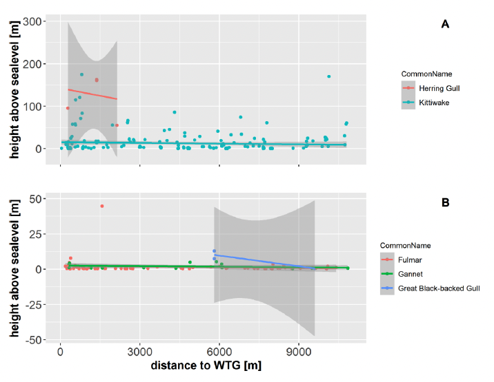
Counting Migrating Bird Populations
Wildlife is rarely modelled in detail in Topographic LiDAR surveys, and when birds in flight are captured, they are often filtered out as high noise. However, when LiDAR surveys are specifically designed for and timed to map as many birds as possible, and the LiDAR Point Cloud is combined with Concurrent Aerial Imagery, it is possible to calculate the number of birds, their flying height and trajectory. Data such as this is critical in understanding the potential impact of proposed offshore wind farms on migrating bird populations.
"While this is an application of Airborne LiDAR that has been somewhat more common in Europe, we are now seeing the application become more common in Australia.", says Sam.
Imaging The Earth
The Earth is approximately 29% land (149M sq km), which would require approximately 500 years to survey entirely using commercial airborne technology. While Aerometrex, like most LiDAR providers, operates airborne systems, it is always worth remembering that there is analogous technology in space, imaging the entire earth’s surface, albeit at lower resolution.
The success of these long-standing programs emphasises the truly scalable applications of LiDAR technology. It may be a long time until LiDAR with equal accuracy and point density can be captured from spaceborne satellites. However, as early as 2003, laser altimeters (analogous technology to LiDAR) have been mapping the elevation of the Earth’s surface within the Geoscience Laser Altimeter System (GLAS) on the Ice, Cloud, and Land Elevation Satellite (ICESat). Since then, subsequent missions such as GEDI (Global Ecosystem Dynamics Investigation) have been using LiDAR technology to map the Earth’s forests and topography.
Airborne Topographic LiDAR, as well as the derived datasets, has become commonplace within a range of industries – being used day to day to support many use cases ranging from forestry, agriculture, to mining and many more.
Beyond topographic LiDAR, in recent years, LiDAR technology has rapidly become a bigger part of our daily lives, with the proliferation of LiDAR technology within self-driving cars and smartphones. As time passes, global experts are bound to come up with many other useful ways in which lidar technology can benefit the world we live in.