13 Mar, 2020
Aerometrex is pleased to announce that the company has won 5 projects of the Queensland Government’s Spatial Imagery Subscription Program (SISP), managed by the Department of Natural Resources, Mines and Energy. The projects won include:
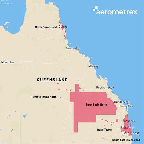
South East Queensland - 10cm
The South East Queensland aerial survey covers an area of 12,365 sq. km. from Noosa Heads in the north to the NSW border, and west to Toowoomba at a very high resolution of 10cm GSD (Ground Sample Distance, or pixel size on the ground)
Surat Basin North - 20cm
The Surat Basin North area, at 149,362 sq. km., is one of the largest aerial surveys conducted in Australia at a resolution of 20cm GSD, which is 2.1x more resolution than the best available commercial satellite imagery.
North Queensland - 10cm
The North Queensland survey covers 17 towns from Cape Tribulation to Kennedy, including Cairns and Innisfail.
Remote Towns North and Rural Towns - 10cm
Remote and Rural towns coverage comprise 10cm imagery to be captured over 23 towns in western and north-western Queensland.
Aerometrex has been a long-time supporter of the Queensland Government’s aerial surveying programs since 2009 and has regularly been awarded work under this annual SISP program. The work is to commence from April through to July and will conclude in Q3 & Q4 2020.
Aerometrex’s Managing Director Mark Deuter commented, “We are pleased to be providing our high- quality imaging service to the Queensland Government programme again this year. Speaking as someone who grew up in outback and rural Queensland, it is particularly pleasing that regional and rural towns will be receiving the same high standard of imagery and data as the urbanised areas of South-East Queensland. We look forward to another successful execution of the programme in 2020.”