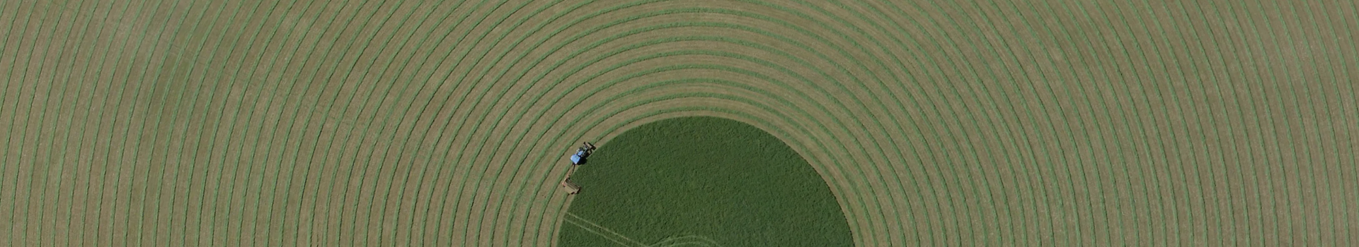
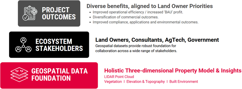
Airborne LiDAR technology is fast becoming a foundational geospatial dataset in Australian agriculture. Across a growing number of projects and applications, it is enabling landowners to boost operational efficiency, optimise land management, diversify commercial outcomes, and improve environmental performance.
At the recent NAFF 2025 conference, our Program & Product Manager, Dr Sam Holt, showcased how airborne LiDAR is empowering landowners and stakeholders to make data-informed decisions through a series of high-impact case studies from across Australia. Below are excerpts from his talk.
Unlike single-use solutions, airborne LiDAR provides a holistic, three-dimensional model of the landscape. Captured via aircraft-mounted laser scanners, it uses pulses of light to generate highly detailed point clouds that map both the terrain and above-ground features such as vegetation and infrastructure.
This ability to accurately model the ground surface, even beneath dense tree canopies, is a key differentiator. The result is a dataset that supports an extensive range of use cases, from water flow modelling to erosion monitoring, informed development applications, vegetation mapping, and even carbon farming.
Landowners retain governance over the data, choosing to either use it directly or collaborate with consultants, agtech providers, or government bodies to achieve their objectives.
LiDAR, short for Light Detection and Ranging, is an active remote sensing technology. It measures the time taken for laser pulses to travel from an aircraft, reflect off surfaces, and return to the sensor. Each pulse can yield multiple returns, producing millions of precise 3D location points per second.
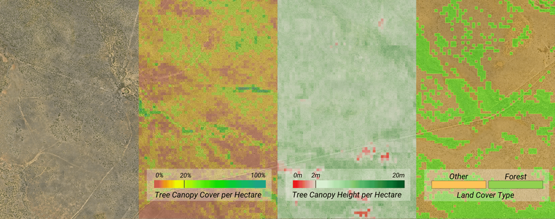
Compared to satellite data or traditional photogrammetry, airborne LiDAR delivers superior vertical accuracy, making it ideal for elevation modelling. It also captures multiple layers of information in a single survey - from the ground to the tops of trees - enabling detailed analysis of both terrain and vegetation.
Visualised as a colourised point cloud, the data forms a realistic and quantifiable 3D representation of the landscape. Aerometrex enhances this further by classifying the data into categories, such as ground, vegetation, and infrastructure, which feed into tailored analytics.
A major strength of Aerometrex’s approach lies in the collaborative design of surveys. Working closely with stakeholders ensures that data capture aligns with end-use priorities, whether it be land development, environmental monitoring, or regulatory compliance.
A single LiDAR survey can yield multiple benefits, from digital elevation models and canopy height layers to erosion risk mapping and asset management insights. Moreover, the data is granular enough that different parts of a property can be analysed independently, enabling whole-of-property management practices, informed by targeted land-use decisions at the paddock level.
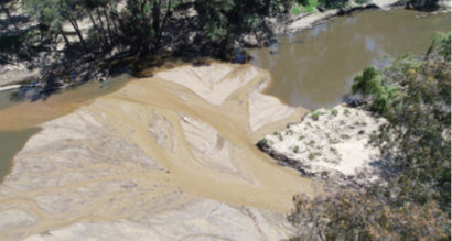
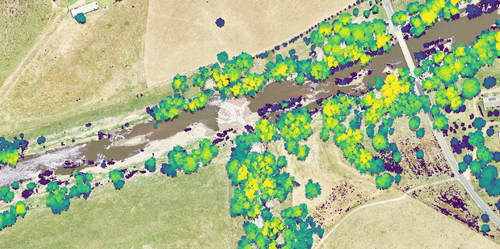
Working with agricultural consultants, Agronomeye, and the Mulloon Institute, Aerometrex delivered a catchment-scale project spanning 88,000 hectares to facilitate property-level management practices informed by holistic catchment-level models and insights. The aim was to build drought resilience and manage erosion risk through detailed terrain and vegetation modelling.
One group of farmers southeast of Cowra, NSW, used the data to address erosion on local agricultural land that was contributing to a 150 km sand slug threatening Murray cod habitat in the Lachlan River, costing producers and the environment. It helped make decisions about where to focus work, which included building structures to change water flow, fencing off creeks and gullies, and revegetating with pastures and native vegetation. The landowners are now actively managing water usage in collaboration with the Mulloon Institute to reduce sediment contribution, demonstrating how LiDAR can enable evidence-based action at both macro and micro scales.
In a smaller, targeted project, Aerometrex worked with MCA Agronomy and local cereal and cotton growers to enhance land development outcomes over 2,100 hectares. MCA Agronomy Service provides integrated whole-farm advice on all aspects of dryland and irrigated crop management.
Here, LiDAR and aerial imagery were used to inform property layout and water management strategies by providing a three-dimensional topographic survey for land development planning and property re-levelling for dryland cropping.
According to the landowners, by improving water infiltration, the exercise helped achieve an average yield increase of 1 tonne per hectare and led to the best result recorded on the property's wheat, with an output of 5.4 tonnes per hectare.
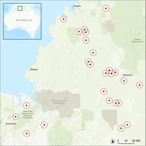
In partnership with the NT Farmers Association, Aerometrex undertook a large-scale LiDAR survey spanning ~250,000 hectares, including a 10,000-hectare pilot at Tipperary Station. The survey aimed to support land care, cropping development, and land-use planning across 20 properties, all while maximising cost-efficiency. The 12-point-per-square-metre dataset, paired with 10 cm aerial imagery, delivered valuable elevation and canopy insights.
One notable outcome was improved water management on farms, where detailed contour and terrain models helped optimise crop layout and slow runoff, potentially enhancing yields. Another benefit was the provision of higher-resolution data than typically available from public sources, strengthening development applications with more accurate slope and terrain assessments.
Aerometrex has also supported multiple carbon farming projects across Central Australia and Southern Queensland, covering over 1.7 million hectares. In collaboration with Agronomeye & Regenco, LiDAR data was used to map vegetation and inform the stratification of carbon estimation areas. Detailed canopy height and coverage metrics helped identify forested zones that meet regulatory criteria for carbon project registration. By establishing accurate baselines, assessing carbon stock, and improving reporting confidence, LiDAR has proven integral to high-integrity carbon projects that offer both environmental and commercial benefits.
The Carbon Farming Initiative (CFI) Mapping Guidelines by the DCCEEW emphasise the importance of accurate geospatial mapping in greenhouse gas abatement projects. According to the Blueprint for a Holistic Approach to Carbon Farming, integrating advanced technologies like LiDAR modernises carbon farming. LiDAR-based mapping also aligns with the Carbon Credits (Carbon Farming Initiative) Act 2011, ensuring compliance with regulatory bodies.
Working with agricultural consultants, Agronomeye, and the Mulloon Institute, Aerometrex delivered a catchment-scale project spanning 88,000 hectares to facilitate property-level management practices informed by holistic catchment-level models and insights. The aim was to build drought resilience and manage erosion risk through detailed terrain and vegetation modelling.
One group of farmers southeast of Cowra, NSW, used the data to address erosion on local agricultural land that was contributing to a 150 km sand slug threatening Murray cod habitat in the Lachlan River, costing producers and the environment. It helped make decisions about where to focus work, which included building structures to change water flow, fencing off creeks and gullies, and revegetating with pastures and native vegetation. The landowners are now actively managing water usage in collaboration with the Mulloon Institute to reduce sediment contribution, demonstrating how LiDAR can enable evidence-based action at both macro and micro scales.
In a smaller, targeted project, Aerometrex worked with MCA Agronomy and local cereal and cotton growers to enhance land development outcomes over 2,100 hectares. MCA Agronomy Service provides integrated whole-farm advice on all aspects of dryland and irrigated crop management.
Here, LiDAR and aerial imagery were used to inform property layout and water management strategies by providing a three-dimensional topographic survey for land development planning and property re-levelling for dryland cropping.
According to the landowners, by improving water infiltration, the exercise helped achieve an average yield increase of 1 tonne per hectare and led to the best result recorded on the property's wheat, with an output of 5.4 tonnes per hectare.
In partnership with the NT Farmers Association, Aerometrex undertook a large-scale LiDAR survey spanning ~250,000 hectares, including a 10,000-hectare pilot at Tipperary Station. The survey aimed to support land care, cropping development, and land-use planning across 20 properties, all while maximising cost-efficiency. The 12-point-per-square-metre dataset, paired with 10 cm aerial imagery, delivered valuable elevation and canopy insights.
One notable outcome was improved water management on farms, where detailed contour and terrain models helped optimise crop layout and slow runoff, potentially enhancing yields. Another benefit was the provision of higher-resolution data than typically available from public sources, strengthening development applications with more accurate slope and terrain assessments.
Aerometrex has also supported multiple carbon farming projects across Central Australia and Southern Queensland, covering over 1.7 million hectares. In collaboration with Agronomeye & Regenco, LiDAR data was used to map vegetation and inform the stratification of carbon estimation areas. Detailed canopy height and coverage metrics helped identify forested zones that meet regulatory criteria for carbon project registration. By establishing accurate baselines, assessing carbon stock, and improving reporting confidence, LiDAR has proven integral to high-integrity carbon projects that offer both environmental and commercial benefits.
The Carbon Farming Initiative (CFI) Mapping Guidelines by the DCCEEW emphasise the importance of accurate geospatial mapping in greenhouse gas abatement projects. According to the Blueprint for a Holistic Approach to Carbon Farming, integrating advanced technologies like LiDAR modernises carbon farming. LiDAR-based mapping also aligns with the Carbon Credits (Carbon Farming Initiative) Act 2011, ensuring compliance with regulatory bodies.
Across all these projects, one common thread emerges: airborne LiDAR serves as a powerful geospatial foundation that informs better decisions. When implemented thoughtfully, through collaborative survey design and stakeholder engagement, LiDAR supports a wide array of outcomes, from improving yields and resilience to unlocking new revenue streams.
As demand grows for more sustainable and efficient land management practices, airborne LiDAR is set to play an increasingly central role in the agricultural sector.
For more information on Aerometrex’s airborne LiDAR services or to explore any of the case studies mentioned, see the resource links below.