How aerial LiDAR supports flood modelling, catchment mapping and coastal erosion monitoring, and when free government data is enough or a new Aerometrex survey is needed.
Flood and erosion models, which identify potential flow paths, depressions and erosion, rely on ground elevation data that aerial LiDAR (airborne laser surveying) can capture. Aerometrex classifies its LiDAR data by assigning each point a category, such as ground, water, vegetation or building, according to standards developed from those established by the Intergovernmental Committee on Surveying and Mapping (ICSM). The reliability of flood models depends on a number of factors, including the age of the data, the accuracy of point classification and the precision of the measurements.
| Custom aerial LiDAR | Free government LiDAR | |
|---|---|---|
| How new is the data? | Flown when you need it | Varies by state. In Queensland, often over 3 years old. |
| Can it see the ground under trees? | Yes, pulses reach the ground through gaps in the canopy | Yes, if the original survey was LiDAR |
| How is accuracy stated? | Vertical, as plus or minus a distance at a stated confidence level | Set by the agency that flew it, in its metadata |
| How fast? | Up to about 4 weeks for a new capture | Ready to download now |
| What does it suit best? | Flood models, catchments and repeat erosion surveys | First studies of areas that have not changed |
| Who sets the spec? | You set the area, classification and outputs | It is fixed by the agency that flew it |
Flood and coastal teams must determine whether freely available government LiDAR accurately represents current ground conditions. Existing data is suitable for areas unchanged since the last public survey, although older datasets may not capture erosion or new residential developments. Where terrain has changed, available data excludes parts of the catchment or lacks sufficient resolution, a new Aerometrex survey, with ground points classified according to standards derived from those of the ICSM, provides a ground model, contours and a baseline for subsequent surveys.
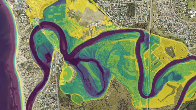
Aerial LiDAR provides flood modelling teams with a bare-earth terrain model covering an entire floodplain. Aerometrex classifies laser points according to its Type 1 standard, derived from ICSM standards, distinguishing ground, water, bridges and culverts. These classified points are used to generate a digital terrain model (DTM) and contours, which flood engineers integrate into geographic information systems (GIS) to identify potential flow paths. Detailed flood modelling also requires additional hydrological conditioning, which involves adjusting the terrain model to represent water movement through features such as culverts and beneath bridges, consistent with actual ground conditions.
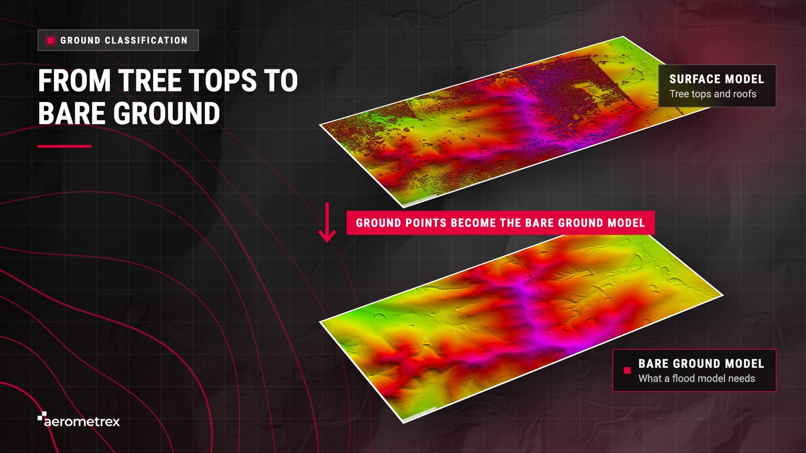
A DTM represents bare-ground elevations, with trees and buildings removed and each pixel (an individual grid cell) recording an elevation above sea level. Contours connect points of equal elevation, similar to the lines shown on topographic hiking maps.
The Aerometrex LiDAR elevation data page presents a DTM with 50 cm pixel resolution and contours at 50 cm elevation intervals.
Flood studies rely on accurate ground elevation data, as the reliability of flood models depends on the quality of the underlying terrain information. The Queensland Government identifies LiDAR capture as critical for defining terrain in flood modelling.
Queensland's Flood Risk Management Program includes a $6 million LiDAR capture and floor level database initiative, made available to 37 councils through funding allocated following the 2021–22 rainfall and flooding events.
In addition to flood modelling, water management teams can utilise the same LiDAR data for three applications:
The cost of a flood survey depends on the survey area and classification type. Aerometrex's Type 1 classification provides a cost-effective option for terrain modelling, although detailed flood modelling may require additional hydrological conditioning. Requirements for ground control and independent accuracy validation are determined by the specified survey accuracy and technical requirements.
Catchment mapping involves measuring ground elevations across an entire river system rather than an individual site. Aerometrex conducts these surveys using aircraft, with its Galilee Basin survey for the Queensland Government covering 115,000 km², approximately half the area of Victoria.
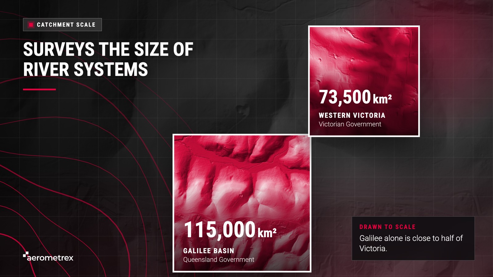
Aerometrex has also conducted aerial surveys covering 73,500 km² of Western Victoria for the Victorian Government. The company participates in state and federal government mapping panels and manages survey planning, aerial acquisition, data processing and quality assurance entirely in-house.
Water movement extends across administrative boundaries, requiring flood models for individual towns to incorporate accurate upstream terrain data. A single survey covering the entire catchment provides all teams with a consistent baseline of ground elevation data.
In agricultural areas, Aerometrex completed a LiDAR survey covering 88,000 hectares of the Hovells Creek catchment in NSW to support drought resilience and erosion risk management. Farmers near Cowra used the data to prioritise erosion mitigation efforts addressing sediment contributions to a 150 km sand slug (an extensive accumulation of sand along the riverbed) in the Lachlan River.
Aerometrex also provided aerial LiDAR data of eroded gullies within Great Barrier Reef catchments as part of a project funded by the Australian Government's Reef Trust.
Geoscience Australia's Murray Darling Basin Elevation Project, covering Australia's largest river system, was developed to support flood modelling of the Murray and Darling rivers, using a ground elevation model derived from LiDAR ground points at 1 m pixel resolution.
Catchment management teams typically require four key outputs from a LiDAR survey.
Aerometrex's LiDAR-equipped aircraft can survey up to 150 km² per day. Existing LiDAR data from previously surveyed areas can be delivered in as little as 24 hours, while new aerial LiDAR acquisitions require up to approximately four weeks.
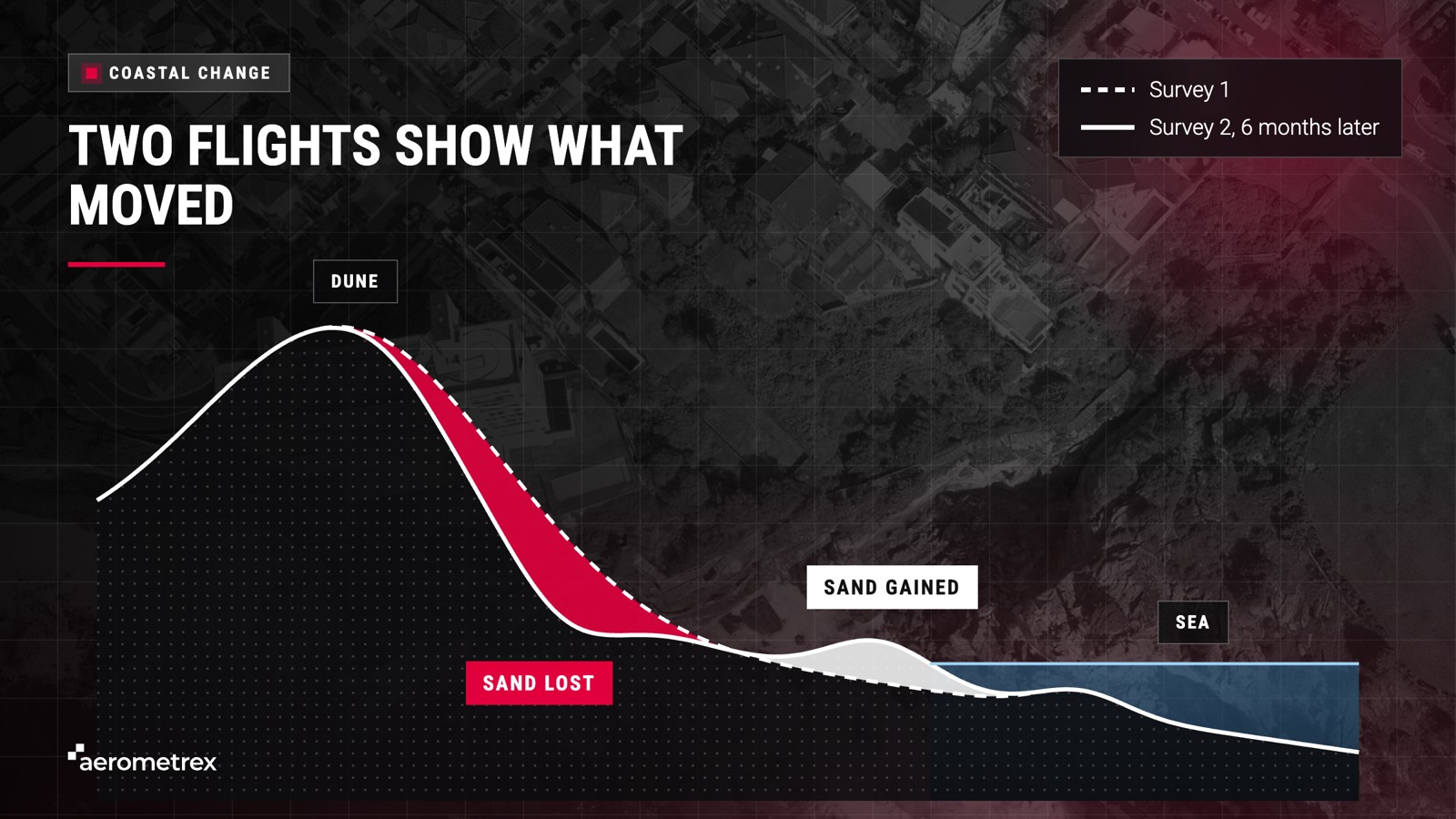
Aerial LiDAR enables coastal erosion monitoring through repeated elevation measurements of the same beach, dune or cliff. Elevation models derived from two separate LiDAR surveys can be compared to identify changes in surface height, supporting the assessment of erosion, landslides, tree canopy loss and earthworks.
Aerometrex schedules coastal LiDAR surveys according to tidal conditions, while the national LiDAR specification established by ICSM recommends surveying coastal areas within two hours before or after low tide. Conducting surveys during periods of reduced vegetation cover also improves the visibility of fine-scale erosion features.
Some councils incorporate repeat LiDAR surveys into their coastal monitoring programs. In Western Australia, the City of Wanneroo conducts LiDAR surveys every six months across its erosion-prone beaches and has monitored coastal erosion since 2014.
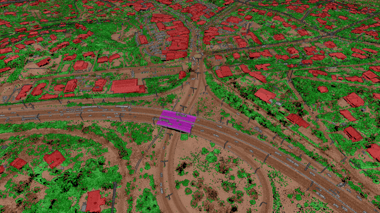
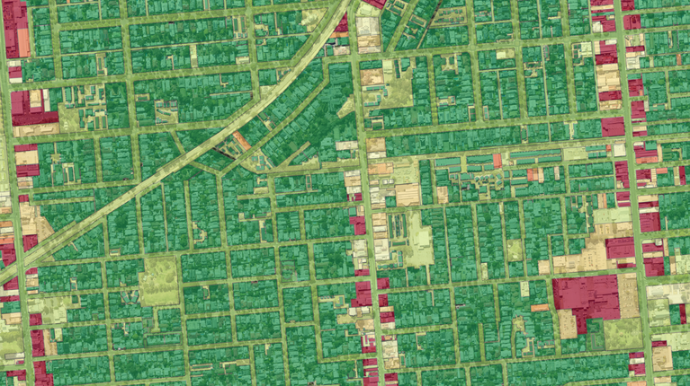
A single LiDAR survey can capture ground, vegetation, buildings and hard surfaces across a large area, which suits environmental monitoring. Aerometrex classifies the laser points using one of its three standard classification types. All three classify the ground at the highest level. Type 2 and Type 3 also classify tall trees and buildings at a higher level than Type 1, which classifies them at the lowest level. Environmental monitoring teams can use this data to assess canopy height and cover. Where repeat surveys exist, they can also map change between them.
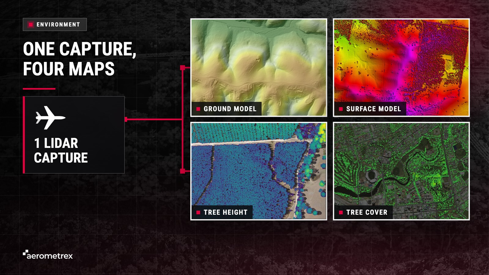
A single LiDAR pulse can register returns from the treetop, branches and ground, allowing one survey to characterise both the canopy and underlying terrain. Aerometrex uses these measurements to produce several mapping outputs:
Hard surface mapping also supports flood assessment by identifying roofs and roads that generate rapid surface runoff and areas where water may accumulate. Aerometrex's community resilience toolset demonstrates how data from a single LiDAR survey can support the assessment of multiple environmental hazards.
The same aerial survey also supports bushfire fuel load mapping, while Aerometrex can provide a preliminary estimate of a property's Bushfire Attack Level (BAL), which indicates its potential bushfire exposure under Australian Standard AS 3959.
Freely available LiDAR data in Australia is primarily sourced from state governments and distributed through ELVIS (Elevation and Depth – Foundation Spatial Data), a national portal developed by government agencies through ICSM. Users can search for and download point clouds and ground elevation models shared by participating agencies. However, these publicly available datasets are often several years old.
In Queensland, state LiDAR data older than three years is freely available through ELVIS, while more recent datasets require purchase, according to the Queensland Globe help page.
Freely available LiDAR provides a useful starting point for many studies, with four key criteria determining its suitability:
| Check | Why it matters |
|---|---|
| Capture date | Floods, storms and new estates change the ground after the flight |
| Coverage | Free data may stop at a boundary that cuts your catchment |
| Classification | A DTM needs ground points classified to ICSM standards |
| Pixel size | A model with 5 m pixels can miss levees, drains and kerbs that steer water |
Freely available data that meets these criteria can be used without further acquisition, as newer data provides additional value only where ground conditions have changed. Where existing datasets are insufficient, Aerometrex can conduct a custom aerial survey or provide previously acquired LiDAR data, with sample datasets available for preliminary evaluation.
Aerial LiDAR measures land surfaces rather than submerged terrain, and Aerometrex does not provide bathymetric (underwater) LiDAR, requiring separate surveys of seabeds and riverbeds. Dense vegetation reduces the number of ground points, while water surfaces produce few usable returns. Addressing these limitations before model development, through separate riverbed surveys or additional ground verification beneath dense vegetation, helps prevent data gaps from affecting modelling results.
Four limitations affect the information aerial LiDAR can provide for flood and coastal assessments:
Before adjustment to ground control (ground-surveyed reference points), Aerometrex LiDAR can achieve a vertical accuracy of ±20 cm at 68% confidence (1 sigma), meaning about 68 in 100 checked elevations fall within 20 cm of the true elevation. When ground control is used, the figure is ±10 cm at 68% confidence, meaning about 68 in 100 checked elevations fall within 10 cm. Aerometrex surveys provide between 1 and 50 points per square metre, with actual specifications varying according to project requirements.
Requirements for ground control and independent accuracy validation depend on the specified survey accuracy and technical requirements. Existing client-provided survey points may also be used, provided they meet aerial survey specifications. Further information on these applications is available on Aerometrex's environment and disaster management page.
Yes, when the ground points are classified to ICSM standards and checked against ground control when it is used.detailed flood modelling can sometimes require additional hydrological conditioning. Aerometrex LiDAR can achieve two vertical accuracy figures: plus or minus 20 cm at 68% confidence without ground control, and plus or minus 10 cm at 68% confidence once adjusted to ground control, though actual specifications vary by project and accuracy may be higher. When comparing providers, ask each one for its height accuracy, the confidence level behind it and whether ground control was used.
A digital terrain model (DTM) shows bare ground, with trees and buildings removed, while a digital surface model (DSM) shows the top of everything, including roofs and treetops. That is why flood models use the DTM while building risk checks use both.
Partly. Laser pulses that pass through gaps in the canopy to the ground can return a measurement. However very thick bush lets fewer through, so the ground model there has fewer measured points.
No. Aerometrex's aerial LiDAR maps the land surface, including beaches, dunes and floodplains, while seabeds and riverbeds need a different survey from another supplier.
How often depends on how fast the coast changes and how much is at risk. Some councils fly LiDAR every 6 months over at-risk beaches, while others fly after storms to measure the damage. How often an area is flown depends on the specific use case and budget.
Yes. The same flight can give flood teams a ground model, tree teams a canopy map and planners building heights, and Aerometrex can also capture aerial imagery during the same flight.