3D Image Dedicated is an innovative, managed Software-as-a-Service (SaaS) solution developed by Esri and Aerometrex. This service provides a seamless and efficient way to access, manage, and share large-scale 3D datasets, eliminating the challenges of traditional methods like manual file transfers or reliance on costly hardware infrastructure.
3D Image Dedicated is the perfect solution for industries and organisations relying on accurate, accessible 3D data to support their projects. This includes local, state, and federal governments, urban planners, engineers, architects, and property developers. It is also invaluable for traffic management authorities, transport planners, and the energy and utilities sector, providing these industries with the tools they need to manage and utilise complex datasets efficiently.
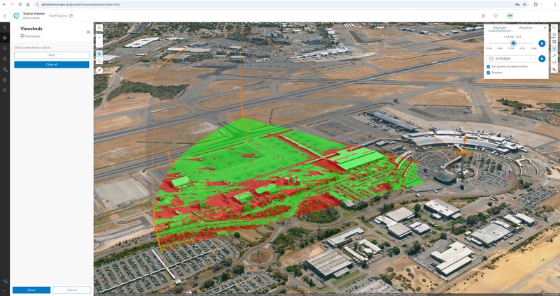
Share and analyse Aerometrex 3D data with the full range of tools available in ArcGIS Online. The image above shows a viewshed analysis of Perth Airport and its surroundings.
Managing massive 3D datasets can be a logistical headache. From time-consuming downloads to the need for high-end IT infrastructure, the traditional approach creates roadblocks that slow your projects and inflate costs.
No more waiting for temporary download links or dealing with hard drive deliveries.
Enjoy the confidence of secure, cloud-based data access.
Eliminate expensive on-premises storage solutions and reduce IT overhead.
3D Image Dedicated uses advanced cloud-hosting technology to deliver data efficiently and securely. Your 3D datasets are stored on our AWS-hosted servers and can be streamed directly into:

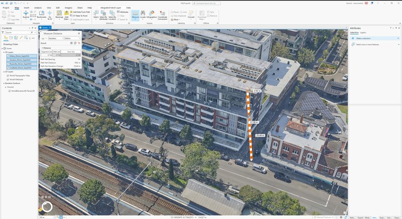
Get more from Aerometrex 3D data with the power of Esri's ArcGIS Pro tools. Measure height from ground, horizontal distance and the direct-line 3D distance.
Have questions about how Aerometrex 3D Image Dedicated can work for your organisation? Our team of experts is here to help. Whether you’re looking to streamline your 3D data management, integrate with existing Esri tools, or explore how this solution can enhance your workflows, we’re here to help.