LiDAR (Light Detection and Ranging) technology has revolutionised data analysis across various industries. By capturing and analyzing aerial LiDAR data, valuable insights can be obtained, benefiting multiple internal departments and stakeholders. One key aspect that enhances LiDAR data's power is the points' classification within the point cloud. This segmentation and classification process allows for detailed analysis of specific features, enabling accurate and targeted decision-making. In this blog post, we will delve into the classification of LiDAR point clouds, exploring its significance, methodologies, and classification types developed by Aerometrex.
The ICSM (Intergovernmental Committee on Surveying and Mapping) has established widely adopted LiDAR point cloud classification standards. These guidelines define the classes used and the associated levels of quality assurance. Aerometrex has developed a proprietary set of classification methodologies over the years aligned to the ICSM standards.
By combining automated methodologies with rigorous manual quality assurance and quality control (QA/QC) processes, Aerometrex ensures the production of highly accurate point cloud classifications.
Aerometrex understands that customers have unique requirements when it comes to point cloud classification. To provide accurate and cost-effective solutions tailored to their specific needs, Aerometrex has developed a range of classification types that adhere to ICSM standards. Let's explore three of these classification types:
Type 1: Accurate Topographical and Ground Surface Elevation Data
[Image: Aerometrex Type 1 Classified LiDAR Point Cloud of a site in Mt Isa, Queensland]
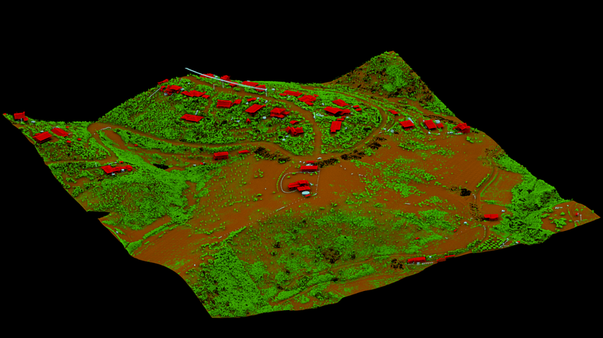
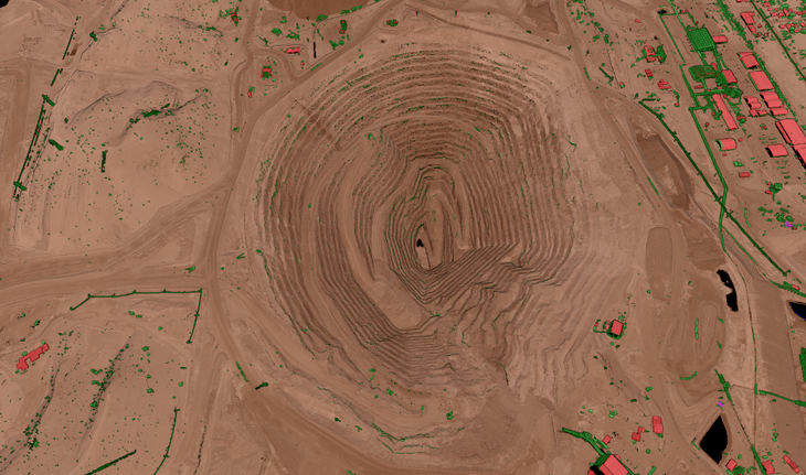
Aerometrex's Type 1 classification is designed for use cases that prioritise accurate topographical and ground surface elevation data. It includes a fully automatic classification of the point cloud, along with targeted manual improvements to Ground, Noise (High & Low), Water, Bridges, and Culverts. This classification type offers a cost-effective solution for deriving Digital Terrain Models and Contours. It finds applications in surface water management, flood modelling, erosion monitoring, and mining operations.
Type 2: Detailed Information on Built Environment and Vegetation
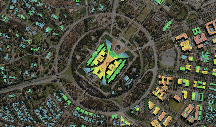
[Image: Building Height Model of Parliament House and surrounds in ACT derived from Aerometrex's Type 2 Classified LiDAR Point Cloud]
Aerometrex’s Type 2 classification builds upon Type 1 and is tailored for projects that require detailed information on the built environment (buildings) and vegetation, in addition to ground surface data. In addition to the automatic classification, Type 2 incorporates targeted manual improvements to High Vegetation, Buildings, and Default Infrastructure. This classification type enables the derivation of datasets such as Building Height Models, Canopy Height Models, Building Footprints, and Tree Canopy Coverages. It proves valuable in urban planning, infrastructure development, and environmental monitoring projects.
Type 3: Holistic 3D Models for Specialised Projects
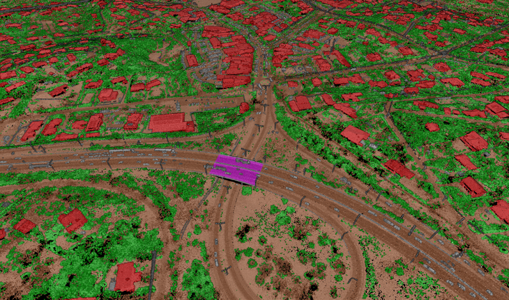
[Image: Aerometrex Type 3 Classified LiDAR Point Cloud]
Aerometrex's Type 3 classification, although costlier, offers a holistic, classified 3D model of the environment, tailored for bespoke and specialised projects. Type 3 incorporates both Type 1 and Type 2 classifications but involves additional manual improvements to Default Infrastructure, Medium Vegetation, High Vegetation, Buildings, and Noise. This comprehensive dataset is ideal for specialised asset management and engineering projects that require more detailed information on small-scale urban features like powerlines, street furniture, and fences.
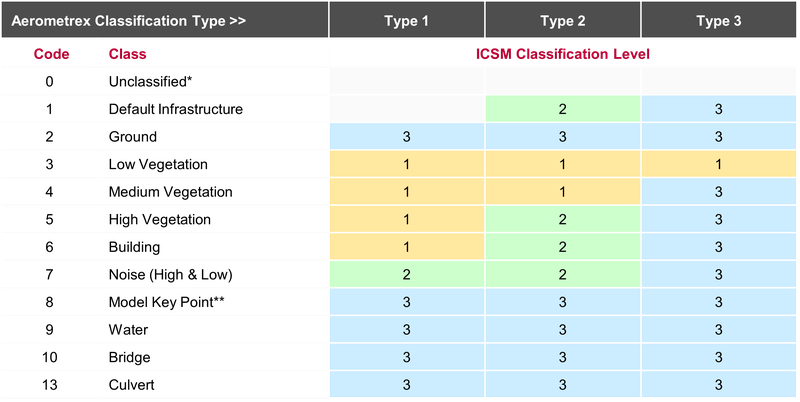
All Aerometrex classification types are built upon ICSM standards. The table below summarises the ICSM classification levels applied to each class for each classification type, further guaranteeing the accuracy and integrity of the resulting data. While Aerometrex has developed the above-listed three key classification types for our LiDAR Point Cloud deliveries, we can custom deliver classified point clouds to other combinations of ICSM classes & levels. This can be done in consultation with clients depending on their end-use.
LiDAR point cloud classification plays a pivotal role in unlocking the potential of LiDAR data across diverse applications. Aerometrex's comprehensive approach to classification, combining automatic methodologies with rigorous manual QA/QC, ensures highly accurate point cloud classifications. By tailoring our classification types to specific use cases and adhering to ICSM standards, we provide customers with cost-effective and tailored solutions for their classification needs. Whether it's obtaining accurate topographical data, detailed information about the built environment and vegetation, or a holistic 3D model for specialised projects, Aerometrex's classification types cater to a wide range of requirements.
Understanding the classification of LiDAR point clouds is essential for leveraging the full potential of this powerful analytical tool. By segmenting and classifying the points within the point cloud, valuable insights can be extracted for applications such as surface water management, flood modelling, asset management, and engineering projects. With Aerometrex's expertise in point cloud classification and adherence to ICSM standards, customers can confidently utilise LiDAR data for their specific needs, ensuring accuracy, efficiency, and informed decision-making.